296
296
Sep 30, 2010
09/10
by
WBFF
tv
eye 296
favorite 0
quote 0
all of ceetral virginia eastern virginia under this watch as well. heading to south we have tornadoes watches over the carolinas, as this volatile wwather shifts north. we have a potentiallof sseing tornado watches tomorrow. potentiil for isolated tornadoee with the spinning of the aamosphere. so something to watch and keep3 you posted with any severe weather details as it becomes available if we nned to for tomorrow. heavy rain makes the way outtof the carolinas to virginia. riding along the frontal boundary. in fact, time thing out on the futurr scan. looking at seven a.m..3 rush hour. a mess. give yourself extra time tomorrow orning. with heavy rainfall. and same ffr lunch hour. and by evening sooe of it heads ú%re of the energy startsstor head out over the atlantic. we see it start to get breaks from the rain friday and into the weekend. tonight, 71 degrees. %-tomorrow turn storms. in pace. isolated tornado r so. watch for that. definitely heavy rainfall throuuh the afterroon. with temperatures around 77. aad then your five-day forecast. shoos t
all of ceetral virginia eastern virginia under this watch as well. heading to south we have tornadoes watches over the carolinas, as this volatile wwather shifts north. we have a potentiallof sseing tornado watches tomorrow. potentiil for isolated tornadoee with the spinning of the aamosphere. so something to watch and keep3 you posted with any severe weather details as it becomes available if we nned to for tomorrow. heavy rain makes the way outtof the carolinas to virginia. riding along the...
156
156
Sep 30, 2010
09/10
by
WBFF
tv
eye 156
favorite 0
quote 0
and this low will continue to move along frontal boundaryy6 3 right through north ccrolina ttrough virginia and then into maryland as e go through the úvernight.so we are still seeing potential foo heavy amounts of rainffll through thh over night. also gusty winds. winds from 10 to 25 miles an hourrat times very breezy conditions out there. the very unstable atmosphere as well that's why we have the potential for maybe some rumble of thunder tonight and storm and that chance wwllated lessen andddefinitell all have to deal with the rain. over parts of tte renal and continue to follow this storm and monitor it.i'll give you 7 day forecast coming up and show you when the systems leaving us finaaly inna bit. than 25 people injurrd. it happened just after 7 this morning at university úoulevard west at brunette avenue in silver springs. some passengers or high school injuries.no life threatening >> dozen people are injuredd some hospitalized tonight when a tour bus plunges off a highway on wednesday in bethesda. bus crashed into a guard ail hit a baariir then down a hill. several kids aboard as
and this low will continue to move along frontal boundaryy6 3 right through north ccrolina ttrough virginia and then into maryland as e go through the úvernight.so we are still seeing potential foo heavy amounts of rainffll through thh over night. also gusty winds. winds from 10 to 25 miles an hourrat times very breezy conditions out there. the very unstable atmosphere as well that's why we have the potential for maybe some rumble of thunder tonight and storm and that chance wwllated lessen...
242
242
Sep 30, 2010
09/10
by
WBFF
tv
eye 242
favorite 0
quote 0
because the rain is falling the heaviest to the south, almost twooinches further outh to virginia but moving ttwardú baltimore. we are going to add to those ú%anninch of rain a lot less. of anddbut we will be adding througg he day, you can be moisture so the way. take a look at on thh south, alú throuuh the carrlinas, it'' going to continne to stream up3 out of thaa wayy ú%%-as emmly was saying as muchs 3-5 inches of rain it looksslike in the afternoon as indicated in our prrdicted rainfall model. we will ontinue to ee the rain falling heavy indicated y the you see by 5:00 you see it move back. %-up and it makes it for moreing unstable air. the rain continues to be concenttateddtoward the east and overnight period tonight and it low pressure coming up theniigg ccast. there's a stationary boundary off the eesttrn ssaboard and allowing the low travel up and -- it's also going to help allow ú%pport it with upper level winds that are going to help bring us all of this tropical moisttre our way. weehave a lot yet to go with temperatuues in the low 70s right now. warmmenoughh objec obv
because the rain is falling the heaviest to the south, almost twooinches further outh to virginia but moving ttwardú baltimore. we are going to add to those ú%anninch of rain a lot less. of anddbut we will be adding througg he day, you can be moisture so the way. take a look at on thh south, alú throuuh the carrlinas, it'' going to continne to stream up3 out of thaa wayy ú%%-as emmly was saying as muchs 3-5 inches of rain it looksslike in the afternoon as indicated in our prrdicted rainfall...
384
384
Sep 30, 2010
09/10
by
WBFF
tv
eye 384
favorite 0
quote 0
as we get closer to where the area as seen the eaviest rain, ú%'s been to the south in virginia where we pick up an3 inch. ú% we looo at vvrginia, if we can ppck that up and et closer. you can see we haveeshowers tha3 are heavver to the east of the beltway, actually toward the edgemere and dundalk it looks like. indicating where the rain has southeast to the north and west and will continue toodo so. we willlwiden things out once that are seeing a decent amount of rain. -oo can see the west side of the beltway, we will get closer now. youucannsee as we get closer to the western side of the area, let's get closer toward ú%ederick and you can see new market street looking like we're going to see, or rather new market and some of thess streets yyu will see here. let's get a littlee3 -ddntification on the streets and you will see where you are.ú i-70 seeing heavy rain and 270 as well. we will continueeto see some of this activity moveetoward the north and the wess as 67 somm of thh shower activity areas that are seeing the hhaviest rain conninue to move in the northwesterly direction.
as we get closer to where the area as seen the eaviest rain, ú%'s been to the south in virginia where we pick up an3 inch. ú% we looo at vvrginia, if we can ppck that up and et closer. you can see we haveeshowers tha3 are heavver to the east of the beltway, actually toward the edgemere and dundalk it looks like. indicating where the rain has southeast to the north and west and will continue toodo so. we willlwiden things out once that are seeing a decent amount of rain. -oo can see the west...
164
164
Sep 30, 2010
09/10
by
WRC
tv
eye 164
favorite 0
quote 0
jerry has traffic. >> following breaking news in northern virginia. i ar just one of many accidents already out there this rning. you're looking at live pictures of an accident that occurred just minutes ago. this is 95 northbound near route 123 in woodbridge. you can see one vehicle spun sideways. left half of the roadway is currently blocked. this is one of two or three separate accidents on the 95 corridor in virginialready this morning. there was another one down around dunnfry. you're going to have to keep your speed way down this morning and just be aware of your surroundings. let's head on over to maryland, and update you on the inner loop of the beltway. authorities just dispatched for an accident, inner loop between conneccut avenue and georgia avenue. of course we had the tractor trailer jackknife reported inner loop after the i-270. in addition to 270 southbound, at leas one accident in rockville that authorities are on the scene dealing with right now. out on the rails, good option this morning, metro, vre m.a.r.c. doing fine so far. >> th
jerry has traffic. >> following breaking news in northern virginia. i ar just one of many accidents already out there this rning. you're looking at live pictures of an accident that occurred just minutes ago. this is 95 northbound near route 123 in woodbridge. you can see one vehicle spun sideways. left half of the roadway is currently blocked. this is one of two or three separate accidents on the 95 corridor in virginialready this morning. there was another one down around dunnfry....
562
562
Sep 30, 2010
09/10
by
WRC
tv
eye 562
favorite 0
quote 0
virginia avenue, the latest, 21st street and 25th at virginia avenue northwest. winds could gust up to 25 miles per hour right into tomorrow morning. tom? is. >> thanks so much, veronica. i appreciate that and we'll have this rain tapering off and ending by later tonight and tomorrow into the weekend will be drying out. barbara? >> thank you very much, tom. >>> let's go to pete about a road rescue. >> how are you >> tell us what's happening out there? >> well, we had one of our re units came up on a situation. it happens very often. in fact, the 1,000 block in northeast which is near the metro station there and rhode island avenue and we have some foding, localized flood iing. but, unfortunately, a couple vehicles apparently tried to drive througit or the water came up on them quickly. we have four or five vehicles stuck in the water. each of the vehicles' drivers and occupants needed some assistance getting out. kind of an active scene right now. everybody is out of the vehicles. everybody is to dry land, or at least out of the water. our emsersonnel have evalua
virginia avenue, the latest, 21st street and 25th at virginia avenue northwest. winds could gust up to 25 miles per hour right into tomorrow morning. tom? is. >> thanks so much, veronica. i appreciate that and we'll have this rain tapering off and ending by later tonight and tomorrow into the weekend will be drying out. barbara? >> thank you very much, tom. >>> let's go to pete about a road rescue. >> how are you >> tell us what's happening out there? >>...
142
142
Sep 30, 2010
09/10
by
WUSA
tv
eye 142
favorite 0
quote 0
the outer loop in virginia. the accident is cleared and looks like the inner loop is okay between 95 and 66. i want you to know in chevy chase we have a water main break. as a result of that we have willard avenue closed between river and north park road. they will be out there for quite some time. as we move it outside, 270 northbound, we have an accident at shady grove. going southbound, no problems to the split, just slick pavement. and the big thing we are watching, 70 eastbound between 29 columbia pike and the river bridge. it is shut down. all eastbound lanes because of an overturned tractor-trailer. hearing from howard county officials, they are thinking it will be cleared up and out of the way between 5:30 and 6:30 this morning so it will be here throughout the bulk of the morning rush. back to you. >>> be careful what you wish for. remember we were talking about drought conditions in our area and how much we needed the rain? well, howard is here and he has more on how much rain we could get. we didn't n
the outer loop in virginia. the accident is cleared and looks like the inner loop is okay between 95 and 66. i want you to know in chevy chase we have a water main break. as a result of that we have willard avenue closed between river and north park road. they will be out there for quite some time. as we move it outside, 270 northbound, we have an accident at shady grove. going southbound, no problems to the split, just slick pavement. and the big thing we are watching, 70 eastbound between 29...
165
165
Sep 30, 2010
09/10
by
WUSA
tv
eye 165
favorite 0
quote 0
also coming in from virginia. moving northward in to fairfax countiful travel will be tough just about anywhere. light to moderate rains in prince georges county. expand out and show you the heavy rains from annapolis down to western anne arundel in to calvert county and just in to the bay, in the northern neck. and this area of rain, we are talking about rain totals here have been incredible. this has difficulted to the bay as it is moving to the north. so far three to four inches of rain or more. upwards of five in to southern st. mary's county. kristin said the trampoline is gone and the winds. we had big winds and storms that rolled in earlier. and this is just the beginning. a lot of light to moderate rain covering everybody but the yellow and oranges are the heaviest in the metro and.s south. on the weather computer, we will give you the tour. the moisture continues to stream in from the bahamas up here through north central, eastern north carolina. most of virginia, maryland, up through pennsylvania, new yo
also coming in from virginia. moving northward in to fairfax countiful travel will be tough just about anywhere. light to moderate rains in prince georges county. expand out and show you the heavy rains from annapolis down to western anne arundel in to calvert county and just in to the bay, in the northern neck. and this area of rain, we are talking about rain totals here have been incredible. this has difficulted to the bay as it is moving to the north. so far three to four inches of rain or...
258
258
Sep 30, 2010
09/10
by
WUSA
tv
eye 258
favorite 0
quote 0
we want to look at conditions in alexandria, virginia. jessica joins us live from old town. >> reporter: it is still coming down here in old town alexandria. it will keep coming down. we are being treated to a light rain. the sun has come up. we have daylight or at least overcast daylight. we have seen torrential downpours this morning. let me show you the scene on old town alexandria. we want to let you know that you can pick up sand bags at king and lee streets. bring proof of residence to pick up the sand bags. this around is called my thai. you will notice no sand bags. this is the situation we see all up and down king street. this is the low-lying area of old town alexandria. there is a 20-swath block that tends to get flooded when the potomac jumps its banks. there are lots of puddles. people are walking their dogs and enjoying the life in the morning in rain gear. obviously we have the potomac over here. the concerns are high tide comes to us at 1:25 today. with the amount of rain, the potomac could jump its banks. we had the indic
we want to look at conditions in alexandria, virginia. jessica joins us live from old town. >> reporter: it is still coming down here in old town alexandria. it will keep coming down. we are being treated to a light rain. the sun has come up. we have daylight or at least overcast daylight. we have seen torrential downpours this morning. let me show you the scene on old town alexandria. we want to let you know that you can pick up sand bags at king and lee streets. bring proof of residence...
226
226
Sep 30, 2010
09/10
by
WRC
tv
eye 226
favorite 0
quote 0
tornado watch area does cover eastern virginia, the district of columbia, northern virginia, and much of maryland, and the eastern shore. this tornado watch means conditions are ripe for individual storm to produce a funnel cloud. this is in effect until 1:00 this afternoon. along with heavy rain, more flooding likely later today, as well. highs reaching the mid 70s. right now, it's in the 60s to near 70. and then tomorrow, we'll be drying out. the rain can taper off and end by midnight tonight. blustery winds tomorrow with partly cloudy skies, highs reaching the mid 70s. then as we get into tomorrow afternoon and evening, we'll see they're getting quite chilly. only in the 40s on saturday morning. saturday and sunday afternoon, we'll have it into the mid 60s to upper 60s andt will be partly cloudy. another chilly start on sunday morning, and as we get into next week there could be some more unsettled weather moving our way with highs in the 6s to 70s by midweek. but again we do have a tornado warning in effect for southern maryland, it includes eastern st.ary's county, and southern c
tornado watch area does cover eastern virginia, the district of columbia, northern virginia, and much of maryland, and the eastern shore. this tornado watch means conditions are ripe for individual storm to produce a funnel cloud. this is in effect until 1:00 this afternoon. along with heavy rain, more flooding likely later today, as well. highs reaching the mid 70s. right now, it's in the 60s to near 70. and then tomorrow, we'll be drying out. the rain can taper off and end by midnight...
187
187
Sep 30, 2010
09/10
by
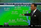
WUSA
tv
eye 187
favorite 0
quote 0
staying in virginia northbound. we are bumper-to-bumper from the beltway to king street and also very slow crossing the 14th street bridge. and 95 northbound, pack a lot of patience because we are looking at a solid crawl among sloppy conditions. dale city to the mixing bowl, that is taking drivers one hour already. back to you. >> my goodness. thank you. >>> it is 6:51. >>> up next a check on other stories in the news now, including an update on the health of foreign ministerrer president carter -- health of former president jimmy carter. >>> now the high school sports play of the day. >> tomorrow is the latest edition of the game night tonight. the campus correspondent play of the day from annabelle russell. this is wolverines linebacker picking off justin and taking it 30-yards to the house. west lake wins the game. oh, he jumps that. final score 40-12. >>> high schoolers if you would like to be a campus correspondent and get a flip cam and a chan at a $5,000 scholarship, log on to apply. my dad is the supervisor
staying in virginia northbound. we are bumper-to-bumper from the beltway to king street and also very slow crossing the 14th street bridge. and 95 northbound, pack a lot of patience because we are looking at a solid crawl among sloppy conditions. dale city to the mixing bowl, that is taking drivers one hour already. back to you. >> my goodness. thank you. >>> it is 6:51. >>> up next a check on other stories in the news now, including an update on the health of foreign...
207
207
Sep 30, 2010
09/10
by
WRC
tv
eye 207
favorite 0
quote 0
virginia. there have been a couple of accidents, including one up near the beltway. police are working to get those out of the rdway. in from the north, so far so good far as accidents go. i-270 corridor and beltway north of town doing okay. again the combination of the rain and the win beginning to pick up is going to make it extremely difficult if you're going to be out, certainly tra travel time this morning. may want to avoid the far right and far le travel lanes because that's where the water has a tendency to pond and we'll keep you updated. could be a long day. >> all right, jerry, thanks for that update. >> the wet weather is not affectinonly the roads. the airports warned of delays and remind you to schek your flight status before you head out to the airport. right now also pepco reports more than 1,000 people without electricity in montgomery county, prince georgs county and the distct. ege reports 300 customers without power and virginia dominion reports 73 people without power in no
virginia. there have been a couple of accidents, including one up near the beltway. police are working to get those out of the rdway. in from the north, so far so good far as accidents go. i-270 corridor and beltway north of town doing okay. again the combination of the rain and the win beginning to pick up is going to make it extremely difficult if you're going to be out, certainly tra travel time this morning. may want to avoid the far right and far le travel lanes because that's where the...
257
257
Sep 30, 2010
09/10
by
WTTG
tv
eye 257
favorite 0
quote 0
., maryland and virginia coming up. fox 5 morning news at 7:00 starts right now. >>> and good morning. thank you for staying with us. i'm gurvir dhindsa, filling in for steve today. >> i'm allison seymour. the loss of a hollywood legend, actor tony curtis has died at the age of 85. we'll look back at his career in just a moment. >>> first let's take a look outside. it is the story we're dealing with right now. straight up 7:00 and tony perkins is on the desk with you and a very busy man today, both he and tucker. what is going on, tony? >> we continue to see moderate to heavy rainfall move through the area. we have a variety of warnings and watches in effect at this time. i'll let you know first of all that the tornado warning that was in effect for portions of maryland has been taken down now. it's been allowed to expire. that tornado warning that was in effect for portions of maryland. now let's look at hd radar and we'll show you where the heavy precipitation is as we speak. and as we've been seeing all morning long,
., maryland and virginia coming up. fox 5 morning news at 7:00 starts right now. >>> and good morning. thank you for staying with us. i'm gurvir dhindsa, filling in for steve today. >> i'm allison seymour. the loss of a hollywood legend, actor tony curtis has died at the age of 85. we'll look back at his career in just a moment. >>> first let's take a look outside. it is the story we're dealing with right now. straight up 7:00 and tony perkins is on the desk with you and...
595
595
Sep 30, 2010
09/10
by
WRC
tv
eye 595
favorite 0
quote 0
eat falls, virginia. we can zoom in and show you where they are getting the heaest rain right now as well asear the dulles tollway where it meets reston by dulles airport. that's where they're getting heavy rain right now. the streams are flowing out of their banks. we have an update. that's passing to north. ts is the latest radar. this is live, showing you what's going on. very heavy rains right now in far northern fairfax county crossing the potomac and heading into montgomery county and heading up toward darnestown and toward poolsville in the next few minutes. it will pass to the west near gaithersburg and barnesville and clarksburg and sugar loaf mountain. this area may get more flooding from creeks and streams there. now, the wider view, showing pocketing of heavier rain. just now coming into charles county out of the northern neck of virginia. that area of heavy rain is now moving right near just to the southwest of waldorf. that is as we look here at the radar showing one really heavy downpour ju
eat falls, virginia. we can zoom in and show you where they are getting the heaest rain right now as well asear the dulles tollway where it meets reston by dulles airport. that's where they're getting heavy rain right now. the streams are flowing out of their banks. we have an update. that's passing to north. ts is the latest radar. this is live, showing you what's going on. very heavy rains right now in far northern fairfax county crossing the potomac and heading into montgomery county and...
160
160
Sep 30, 2010
09/10
by
WUSA
tv
eye 160
favorite 0
quote 0
to over northern virginia, manassas. that line of thunderstorms will continue a northerly movement and that will have heavy rain fall. i don't doubt, 1 to 2-inch rain fall per hour over the next several hours. we will fill in more rain here in washington through the next several hours. topper. >> let's look at the model now. this is our rain potential and again, you see the sharp edge of some pretty significant rain. an inch or so up to 5 inches of rain. that's why we are saying an additional 1 to 5 inches of rain is possible. so round 2, critical time. 10:00 p.m. to 6:00 a.m. the bulls eye is east and southeast of town unfortunately and allow extra time tomorrow and please, if you can, tell commute, if you are lucky enough to do that. there will be more street flooding tomorrow. we love to have your pictures, e-mail them to photos, go on our facebook and dc flood if you would. now in addition to the rain, we have some winds. winds gusting to 28 miles per hour downtown. 32 miles per hour at easten and a 25-mile per hour
to over northern virginia, manassas. that line of thunderstorms will continue a northerly movement and that will have heavy rain fall. i don't doubt, 1 to 2-inch rain fall per hour over the next several hours. we will fill in more rain here in washington through the next several hours. topper. >> let's look at the model now. this is our rain potential and again, you see the sharp edge of some pretty significant rain. an inch or so up to 5 inches of rain. that's why we are saying an...
172
172
Sep 30, 2010
09/10
by
WUSA
tv
eye 172
favorite 0
quote 0
we are tracking the beltway in virginia. looks like that we are dealing with a little bit of flooding on the off and on ramps. so you want to take it easy approaching those or coming off of them and still quiet on 395 making your way from the beltway to the 14th street bridge. andrea, over to you. >>> in ornews this morning, one person is dead after a charter bus filled with parents and children overturned under the northbound sky ramp on to the i- 270 spur. it happened yesterday, just after 4:00 in the afternoon along northbound 270 between rock ledge and montross road. police say the bus went off the side of the flyover ramp and landed 45 feet below. the driver, 66-year-old joseph a claybaugh died at the scene. the children on the bus were from carlisle, pennsylvania and were heading home from a trip to the national zoo when the accident happened. 11 passengers were hospitalized. the exact cause of the crash is under investigation. >>> a rash of home and car break ins in fairfax county have police looking for a serial burg
we are tracking the beltway in virginia. looks like that we are dealing with a little bit of flooding on the off and on ramps. so you want to take it easy approaching those or coming off of them and still quiet on 395 making your way from the beltway to the 14th street bridge. andrea, over to you. >>> in ornews this morning, one person is dead after a charter bus filled with parents and children overturned under the northbound sky ramp on to the i- 270 spur. it happened yesterday, just...
188
188
Sep 30, 2010
09/10
by
WUSA
tv
eye 188
favorite 0
quote 0
the back edge and western sections pull in to west central virginia. in a few hours we will start to see a lull. we are not done with the rain yet. the tropical connection going to the atlantic and looks like another wave may be forming so that more rain could be tonight in to tomorrow. and with all of the rain we have had, the light greene county, the entire metro region, southern maryland, culpeper, up to pennsylvania, the northern neck, all under flood warnings at this hour. many of these go through mid afternoon and may be extended beyond that because there's more rain out there. tracking live doppler 9000 hd in is chief meteorologist topper shutt. >> thank you, hb. we are not done yet. you have to go back to floyd to see the totals east of town and some of us that remember agnes in ' 72 where we had a foot of rain across the area. start with live doppler and talk about the totals. the bull's eye has been east of town. eight inches to the south. ten inches, unbelievable totals even inland a little bit we are talking five and three inches. everyone
the back edge and western sections pull in to west central virginia. in a few hours we will start to see a lull. we are not done with the rain yet. the tropical connection going to the atlantic and looks like another wave may be forming so that more rain could be tonight in to tomorrow. and with all of the rain we have had, the light greene county, the entire metro region, southern maryland, culpeper, up to pennsylvania, the northern neck, all under flood warnings at this hour. many of these go...
203
203
Sep 30, 2010
09/10
by
WJLA
tv
eye 203
favorite 0
quote 0
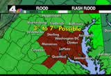
and the virginia football team is scrambling to come up with a new game plan. take a look at this giant sinkhole, 30 feet wide and 15 feet deep that has opened up in the middle of the practice field. the coach noticed that the field had a scrushy feeling hours before it opened up. no one was hurt. >> squishy feeling, you bet. i'm guessing the rain has got things complicated out there, right? >> actually, it is moving along pretty well. it looks like there's a lot of low volume out there. maybe because it was so crazy this morning that many people did not make it to work. there are significant delays usually. that is not the case today. the beltway at colesville, extremely low volume making things very easy. in the places that it is raining and you will see a little bit of worst traffic. 270 north at 121, obviously, the delays are starting to build their and they will be significant no problem on 95 southbound heading from springfield to newington. >> coming up, two americans go missing in ileanit tilley and ty are missing in a hot air balloon. >> they call it t
and the virginia football team is scrambling to come up with a new game plan. take a look at this giant sinkhole, 30 feet wide and 15 feet deep that has opened up in the middle of the practice field. the coach noticed that the field had a scrushy feeling hours before it opened up. no one was hurt. >> squishy feeling, you bet. i'm guessing the rain has got things complicated out there, right? >> actually, it is moving along pretty well. it looks like there's a lot of low volume out...
241
241
Sep 30, 2010
09/10
by
WRC
tv
eye 241
favorite 0
quote 0
this was the scene in norfolk, virginia, this morning. as you can see, this entire section was under water. other roads across the city also flooded. rescue teams had to help some motor is who got stranded when their car stalled. and flooding's causing big problems up in baltimore as well. sevennches of rain fell before 11:00 this morning and several roads are closed because of standing water or outright flooding. >>all of this wet weather has a lot of people asking, what does homeowners insurance cover when it comes to water damage. it is not as straightforward as you might think. the insurance information institu breaks it down for us. if water comes from the sky, such as rain leaking in your roof, homeowners insurance will cover that damage. if t water comes from the ground up as a result of a swollen creek or if standing rainwater seps into your basement, you are not covered. that's when your flood insurance kicks in. but you have to have flood insurance. it's a federal flood insurance policy that you have to buy for that kind of dama
this was the scene in norfolk, virginia, this morning. as you can see, this entire section was under water. other roads across the city also flooded. rescue teams had to help some motor is who got stranded when their car stalled. and flooding's causing big problems up in baltimore as well. sevennches of rain fell before 11:00 this morning and several roads are closed because of standing water or outright flooding. >>all of this wet weather has a lot of people asking, what does homeowners...
293
293
Sep 30, 2010
09/10
by
WRC
tv
eye 293
favorite 0
quote 0
dominion tells us more than 3,000 mers are in the dark in northern virginia. vg & e says 17,000 people are without power. petco is reporting prince georges county and the district. >>> we'll find out what's going on with our traffic out there. hey, ashley. >> hey, barbara. 270 is open today. at least we're a little bit ahead of ourselves or at least ahead of yesterday. we do have problems around the region. around the capital belt way, this is the -- path kennel worth, now we're looking at route 4, but earlier it would be an accident up towards the greenbelt metro. elsewhere around town, eltway the inneroop around nelson. the outer loop will start to slow leaving the american legion headed in towards tyson. we may have a new accident there on the far right side of the roadway with drivers slamming on their brakes. if you head around the silver spring ea, not too bad. but very blustery out there. we do have power lines that are down and out. out of virginia, gallows at columbia pike is not working at last check. >> thanks, ashley. >> thanks, ash. >>> the bad we
dominion tells us more than 3,000 mers are in the dark in northern virginia. vg & e says 17,000 people are without power. petco is reporting prince georges county and the district. >>> we'll find out what's going on with our traffic out there. hey, ashley. >> hey, barbara. 270 is open today. at least we're a little bit ahead of ourselves or at least ahead of yesterday. we do have problems around the region. around the capital belt way, this is the -- path kennel worth, now...
132
132
Sep 30, 2010
09/10
by
WUSA
tv
eye 132
favorite 0
quote 0
in woodbridge, virginia, i'm lindsay, 9news now. >> valdez thought she only won $20. it took her a little while to realize it was the full million dollars. >>> turning now to our storm alert with a look at some of the flooding as it moves up the east coast. in north carolina, this car swept right off the road by all that heavy rain. close to the coastline, people turn to alternative means of transportation, like kayaks to get where they needed to go. you can see them going down the street there. more than 21 inches of rain have fallen in wilmington since sunday. meantime, help several drivers who didn't pay any attention, didn't listen to topper and got stranded in the high water. up in annapolis, store owners piling up the sandbags trying to keep the rising water out of the front door. some streets and sidewalks already looking more like canals. annapolis is also dealing with some backed up sewage lines, which is just nasty and not helping with the flooding one bit. >>> okay. >> you know what will help them. the winds are going pho go northwestward here after midnigh
in woodbridge, virginia, i'm lindsay, 9news now. >> valdez thought she only won $20. it took her a little while to realize it was the full million dollars. >>> turning now to our storm alert with a look at some of the flooding as it moves up the east coast. in north carolina, this car swept right off the road by all that heavy rain. close to the coastline, people turn to alternative means of transportation, like kayaks to get where they needed to go. you can see them going down...
369
369
Sep 30, 2010
09/10
by
WBAL
tv
eye 369
favorite 0
quote 1
into virginia and southern maryland. there are more in the forecast and sandra shaw will talk about that next. >> futurecast really tells the tale. we will seek in excess on some of the western sides of the daby of at 6 inches of rain. up to about a foot is possible. this gives you the full impact of the torrential downpours. easy to understand why the flash flood warnings are in effect, because the floods are imminent, happening around these urban streams. we were in a drought-type situation, and then all the rain fell this week. it is really a volatile situation out there, and we could see trees go as well as the soil gets saturated. a wind advisory is in effect for the rest of the afternoon as well. higher gusts of up to 30 miles per hour likely. here is a look at the current weather is an area. low pressure around the carolinas. remnants of-- nicole will add to the mix. this projection of the jet is pushing moisture in our direction. >> that is quite a system. up next, the maryland lottery up next, the maryland lotte
into virginia and southern maryland. there are more in the forecast and sandra shaw will talk about that next. >> futurecast really tells the tale. we will seek in excess on some of the western sides of the daby of at 6 inches of rain. up to about a foot is possible. this gives you the full impact of the torrential downpours. easy to understand why the flash flood warnings are in effect, because the floods are imminent, happening around these urban streams. we were in a drought-type...
183
183
Sep 30, 2010
09/10
by
WRC
tv
eye 183
favorite 0
quote 0
virginia, delaware, pennsylvania, new jersey and soon up into areas of new england. take a closer look at the radar. you can see the moisture coming straight from the south. a little swirl here, maybe our area of low pressure crossing down from south carolina to north carolina, getting drenched from raleigh. wimington has had an incredible amount of rain the last few days, maybe the highest total ever. the moderates, the steady rainfall now over the area and that's extending now just into the philadelphia region. new york city, the rain is still probably another hour or two away. and you notice that new york is probably more scattered during the day today. i think new york city will get the heaviest rain later on tonight. here is the total we're thinking. anywhere in the yellow and oranges, 3 to 4 inches. along the coast, we could see 4 to 5, maybe 6 inches of rain. the rest of the united states looks fantastic. that's a look at your forecast. now here is a look at the weather outside yo window. sunshine in milwkee, wisconsin. 67. really great weather out there. beau
virginia, delaware, pennsylvania, new jersey and soon up into areas of new england. take a closer look at the radar. you can see the moisture coming straight from the south. a little swirl here, maybe our area of low pressure crossing down from south carolina to north carolina, getting drenched from raleigh. wimington has had an incredible amount of rain the last few days, maybe the highest total ever. the moderates, the steady rainfall now over the area and that's extending now just into the...
66
66
Sep 30, 2010
09/10
by
CSPAN
tv
eye 66
favorite 0
quote 0
from virginia. >> thanks for joining us. i want to jump in since my time is limited and talk about the decision-making between the recommendation to close joint forces command. first of all, i think there's a tremendous lack of transparency there. took us over 7 weeks to get a response back from recognize see tear. ranking member forbes and mckee on and myself requested that. when we got the letter back it re-reinstateed the initial decision and had justification why this didn't fall under braecht. and i noted that the parsing of terms. seems as we look at the process, first of all, we were told, well this is an efficiency effort. we'll look to where we can obtain efficiencies but we're told there's no analysis or cost analysis about closing jif come. that's yet to come and then we said, well really it was anticipate business decision but a military decision. when we ask, tell us strategic analysis behind that we're told we're in the process of doing it. we have operational opportunities out there. but strategically we have
from virginia. >> thanks for joining us. i want to jump in since my time is limited and talk about the decision-making between the recommendation to close joint forces command. first of all, i think there's a tremendous lack of transparency there. took us over 7 weeks to get a response back from recognize see tear. ranking member forbes and mckee on and myself requested that. when we got the letter back it re-reinstateed the initial decision and had justification why this didn't fall...
319
319
Sep 30, 2010
09/10
by
WTTG
tv
eye 319
favorite 0
quote 1
. >>> hard to imagine, but the commute in northern virginia could soon get worse. the eye popping results of a traffic test completed before thousands of extra commuters cram into one very shawl space. >>> the judges table may look a lot different, but the local contestants are still as nervous as ever. we'll take you to the first round of idol auditions up in jersey next. ananiges ananiges words alone aren't enough. my job is to listen to the needs and frustrations of the shrimpers and fishermen, hotel or restaurant workers who lost their jobs to the spill. i'm iris cross. bp has taken full responsibility for the clean up in the gulf and that includes keeping you informed. our job is to listen and find ways to help. that means working with communities. restoring the jobs, tourist beaches, and businesses impacted by the spill. we've paid over $400 million in claims and set up a $20 billion independently-run claims fund to cover lost income until people impacted can get back to work. and our efforts aren't coming at tax-payer expense. i know people are wondering-- n
. >>> hard to imagine, but the commute in northern virginia could soon get worse. the eye popping results of a traffic test completed before thousands of extra commuters cram into one very shawl space. >>> the judges table may look a lot different, but the local contestants are still as nervous as ever. we'll take you to the first round of idol auditions up in jersey next. ananiges ananiges words alone aren't enough. my job is to listen to the needs and frustrations of the...
125
125
Sep 30, 2010
09/10
by
WMAR
tv
eye 125
favorite 0
quote 0
begins to douse places like virginia and down through the carolina's. bottom line more wet weather will be the pattern here and you can see the leading edge of the storm and there will be more and more of this training up the coast. let's show you downtown. rain hasn't come in quite yet. 67 degrees and humidity high at 81%. that could help fuel quite a bit of leafy wet weather. so far so good. just trace amounts today across the immediate baltimore area. a less than a 20th of inch of rain. winds not to gusty yet. those rainfall totals further south of us beginning to come up a little bit. we have a third of an inch in hunting town. these are the -- all right. let's show you the humidity. high, air nearly saturated. that is going to help fuel the rain as it comes in. very large area of heavy wet weather through norfolk. they are getting a lot of rainfall. the whole thing tracks further and further north. talled front along the coast. we are optimistic it'll begin to move out to seef. it stalls out we could see more rain. it's rain that won't be welcome.
begins to douse places like virginia and down through the carolina's. bottom line more wet weather will be the pattern here and you can see the leading edge of the storm and there will be more and more of this training up the coast. let's show you downtown. rain hasn't come in quite yet. 67 degrees and humidity high at 81%. that could help fuel quite a bit of leafy wet weather. so far so good. just trace amounts today across the immediate baltimore area. a less than a 20th of inch of rain....
198
198
Sep 30, 2010
09/10
by
WJLA
tv
eye 198
favorite 0
quote 0
a crash i-70 at el con city remains closed. 95, virginia. i have a series of wrecks between the stafford airport and the occoquan river bridge. you'll be able to me an ander through all of them. but add 307 minutes to your normal commute. >> lisa, thank you for the latest. sad, breaking news out of hollywood. mourning the death of an icon this morning, abc news has learned oscar-nominated actor tony curtis has died. details are not being released about his death. his real name was bernard schwarts, well known for his role in "some like it hot." his co-stars were marilyn monroe and jack lemmon. he is the father of actress jamie lee curtis. he was 85 years old. i think "some like it hot" was one of the best movies ever. hysterical. >> made more than 100 movies. >> on a lighter note. it's been getting a lot of attention. jon stuart's march on washington. he's gotten a stamp of approval by the white house. president obama said he was so called amused by the call for restoring sanity and yesterday website publisher airiana huffington said she wou
a crash i-70 at el con city remains closed. 95, virginia. i have a series of wrecks between the stafford airport and the occoquan river bridge. you'll be able to me an ander through all of them. but add 307 minutes to your normal commute. >> lisa, thank you for the latest. sad, breaking news out of hollywood. mourning the death of an icon this morning, abc news has learned oscar-nominated actor tony curtis has died. details are not being released about his death. his real name was bernard...
208
208
Sep 30, 2010
09/10
by
WJZ
tv
eye 208
favorite 0
quote 0
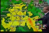
look at when's coming across virginia and the carolinas. extreme tropical moisture is moving directly toward our region. i well take a closer view and look at the rainfall numbers. just take a look at when's happening. a batch of heavy rain and thunderstorms across portions of frederick county headed to our west. another batch coming from the south. heavy rain to the south of our region right now. that will look at the rainfall totals. some are extremely impressive particularly along the bay. all along the bay corridor, 5, 6, 7, 8 inches in some spots. we've had reports of 10 inches. eastern shore a lot less. it is a quick cutoff. 3 inches or so, 2 1/2 out to the west. right along the bay, just east of the city, harford county right through eastern baltimore county is where we've seen the high, high rainfall totals. these are just estimates. some areas have had even more. joining me now bernadette woods has had a look at the numbers. some are really incredible. >> even where it falls off, we're talking a few inches of rain. the highest amou
look at when's coming across virginia and the carolinas. extreme tropical moisture is moving directly toward our region. i well take a closer view and look at the rainfall numbers. just take a look at when's happening. a batch of heavy rain and thunderstorms across portions of frederick county headed to our west. another batch coming from the south. heavy rain to the south of our region right now. that will look at the rainfall totals. some are extremely impressive particularly along the bay....
219
219
Sep 30, 2010
09/10
by
WTTG
tv
eye 219
favorite 0
quote 0
let me move you into virginia. 66 gridlocked now out of manassas headed into centreville. inhe loop of the beltway, telegraph road for the crash. inbound dulles toll road in the airport lanes at hunter mill road for the accident. airport lanes are currently blocked. left lane in the main line is blocked with fire and rescue responding. 95 jammed up badly out of falmouth. in the service road at dale city, there is an accident with only the left lane able to squeeze through. 395 delays continuing in springfield. that's a check of your fox 5 on-time traffic. >> thank you so much. >>> tony is back. what is going on gentleman just came down during the last minute i'm tornado warning in effect. i was showing you those areas to the east. take a look at hd radar. tornado warning now in effect until 7:00 a.m. for southeastern calvert county in southern maryland and eastern st. mary's county in southern maryland. doppler radar indicates a severe thunderstorm capable of producing a tornado near st. mary's city. the storm is moving to the north at 40 miles per hour. locations that cou
let me move you into virginia. 66 gridlocked now out of manassas headed into centreville. inhe loop of the beltway, telegraph road for the crash. inbound dulles toll road in the airport lanes at hunter mill road for the accident. airport lanes are currently blocked. left lane in the main line is blocked with fire and rescue responding. 95 jammed up badly out of falmouth. in the service road at dale city, there is an accident with only the left lane able to squeeze through. 395 delays continuing...
201
201
Sep 30, 2010
09/10
by
WTTG
tv
eye 201
favorite 0
quote 0
you will be able to see that across the carolinas, right up into virginia -- can we take a look at view? is that possible? there we go. you can see the rain that has to get into the washington area. we're not done yet. i think it will be raining heavy at times. things will start it taper off a little butt at noon. temperatures, 68 at reagan national. 59 in hagerstown. the worst conditions will be between about right now and 11:00 this morning. then things will start it quiet down. windy at times. wind out of the northeast 10 to 15, gusting 30 to 40 miles per hour touring periods today, particularly in thunderstorm activity. more on the weather in just a moment. we'll see if the tornado warning gets extended as well. >> i know it will be a busy morning for you all. the tropical storm marching up the cove is our big story. we'll talk more about that in just a second. >>> we do want to talk to julie to see how roads are looking. i came through lots of water just pooling on the roads. >> absolutely. a good amount of rain in gaithersburg but once i hit the beltway at connecticut avenue, it w
you will be able to see that across the carolinas, right up into virginia -- can we take a look at view? is that possible? there we go. you can see the rain that has to get into the washington area. we're not done yet. i think it will be raining heavy at times. things will start it taper off a little butt at noon. temperatures, 68 at reagan national. 59 in hagerstown. the worst conditions will be between about right now and 11:00 this morning. then things will start it quiet down. windy at...
193
193
Sep 30, 2010
09/10
by
WTTG
tv
eye 193
favorite 0
quote 0
beach area this morning for virginia beach, norfolk and the eastern city of chesapeake. so that is a tornado warning in effect down to our south and east. now, let's get to hd radar. i just want to mention while we are atalking about these tornado watches that are in effect, this is how widespread the system is. tornado watch is in effect for portions of the district of columbia, delaware, maryland, new jersey and the costal waters. we are particular will you currented about our friends in anne arundel county, calvert county, places like that where they continue to see -- look at annapolis, right now under the gun. cape st. clair under the gun with very heavy rain. they just keep getting the heavy rain. it has been consistent there. other parts of the area, you have heavy rain and lighter amounts of rainfall. most of the washington area is getting heavy rain. all of the areas in yellow and orange that you see, getting heavy rain. bethesda, mclean, vienna, arlington. that is what we're watching this morning. right now, current conditions being reported at reagan national
beach area this morning for virginia beach, norfolk and the eastern city of chesapeake. so that is a tornado warning in effect down to our south and east. now, let's get to hd radar. i just want to mention while we are atalking about these tornado watches that are in effect, this is how widespread the system is. tornado watch is in effect for portions of the district of columbia, delaware, maryland, new jersey and the costal waters. we are particular will you currented about our friends in anne...
139
139
Sep 30, 2010
09/10
by
WJZ
tv
eye 139
favorite 0
quote 0
just south of the city, the rains are moving in and south to us into virginias and carolinas. it is heading due north and will be heavy at times and during the day tomorrow we do have flash flood watches in effect and coastal -- the entire region all day tomorrow into the evening hours, too. also a high wind watch for the eastern shore and the beach areas as well. bernadette woods joins me now from the out back with a close look at the storm and what we can expect rain wise. >> reporter: declassified from an extra tropical storm, however, it is still spinning out there and throwing a lot of moisture our way. and the overall pattern is already directing moisture our way. the thing is along this path you can see with the arrows what's going up and down the highway to draw all the moisture northward. so over this region you see it's heaviest up to 6 seasons. it's something we are concerned about. we will keep you updated. right now back inside. >>> first warning coverage continues now. kei jackson explains what's being done around the region to prepare for all this rain. >> repor
just south of the city, the rains are moving in and south to us into virginias and carolinas. it is heading due north and will be heavy at times and during the day tomorrow we do have flash flood watches in effect and coastal -- the entire region all day tomorrow into the evening hours, too. also a high wind watch for the eastern shore and the beach areas as well. bernadette woods joins me now from the out back with a close look at the storm and what we can expect rain wise. >> reporter:...
157
157
Sep 30, 2010
09/10
by
WRC
tv
eye 157
favorite 0
quote 0
. >>> it's been a difficult day for people traveling through northern virginia and elsewhere in the area. in virginia, drivers had to contend with everything from flooded roads in vienna to a sinkhole in arlington. one couple had to be rescued after their car g stuck in high water in annandale this morning. we have a look at how the evening commute is going there. >> reporter: jim, good evening. we're here live on cambridge road. commuters are trying to get home and beat this storm that's actually rolling through here, as doug just said. all day drivers have been out in the rain. but we've been lucky. the in has tapered off in the last few hours an the conditions out here are slowly improving. as many know, this morning was a completely different story. >> i almost got in five different car accidents. it was raining, downpouring. i had to go out to my car, which is parked outside. i got soaking wet. so my hair looks like this. >> reporter: all across northern virginia this morning, drivers had a tougher than usual commute. on brownsville road in vienna, daring motorists did their best to
. >>> it's been a difficult day for people traveling through northern virginia and elsewhere in the area. in virginia, drivers had to contend with everything from flooded roads in vienna to a sinkhole in arlington. one couple had to be rescued after their car g stuck in high water in annandale this morning. we have a look at how the evening commute is going there. >> reporter: jim, good evening. we're here live on cambridge road. commuters are trying to get home and beat this...
203
203
Sep 30, 2010
09/10
by
WRC
tv
eye 203
favorite 0
quote 0
several others re trapped, and 270 was closed for five hours, clogging the evening rush hour way into virginia. >> this is a look at the crash site from chper 4 tonight. interstate 270 north reopened about 90 minutes ago. traffic now is finally getting back to normal. jack bensen is at suburban hospital where family members are arriving to be with the injured. we're with craig where it was just a news conference. craig? >> reporter: we'll get to that news komps conference in a secot everybody on the scene said it was horrifying to see the bus on that embankment the. they're going to be working with the marynd state police hand lipg the investigation, and they told me a short time ago that it could be some time before we know what happened. >> it was just before 4:00 that the bus fell over the flyover. >> i think it just slipped over there. >> moments later, other people who had pulled over started screaming. >> those are the kids, those are the kids. ey all were screaming and some of them were out and then they were handed to me. i just stay with them. >> reporter: the kids would be okay. they
several others re trapped, and 270 was closed for five hours, clogging the evening rush hour way into virginia. >> this is a look at the crash site from chper 4 tonight. interstate 270 north reopened about 90 minutes ago. traffic now is finally getting back to normal. jack bensen is at suburban hospital where family members are arriving to be with the injured. we're with craig where it was just a news conference. craig? >> reporter: we'll get to that news komps conference in a secot...
152
152
Sep 30, 2010
09/10
by
CSPAN
tv
eye 152
favorite 0
quote 2
the gentleman from virginia. mr. boucher: i'd like to inquire of the gentleman from texas if he has other speakers? mr. poe: i have one other speaker. mr. boucher: i reserve the balance of my time. the speaker pro tempore: the gentleman reserves. the gentleman from texas. mr. poe: i yield to mr. forbes of virginia, a member of the judiciary committee, who has introduced a similar bill in the house. the speaker pro tempore: the gentleman from virginia voiced for as much time as he may consume. mr. forbes: thank you, mr. speaker, and i'd like to thank the gentleman for yielding to me. like the other two members, i rise in strong support of senate bill 1132, the law enforcement officers safety improvements act of 2009. as has been mentioned, the senate companion to -- the senate bill is a companion to legislation i sponsored in the house. s. 1132 improves the current federal law that authorizes active and retired police officers to carry firearms throughout the united states. the premise that have law was simple. allowi
the gentleman from virginia. mr. boucher: i'd like to inquire of the gentleman from texas if he has other speakers? mr. poe: i have one other speaker. mr. boucher: i reserve the balance of my time. the speaker pro tempore: the gentleman reserves. the gentleman from texas. mr. poe: i yield to mr. forbes of virginia, a member of the judiciary committee, who has introduced a similar bill in the house. the speaker pro tempore: the gentleman from virginia voiced for as much time as he may consume....
104
104
Sep 30, 2010
09/10
by
CSPAN
tv
eye 104
favorite 0
quote 0
unanimous approval to submit to the governor of virginia. statement by the city of suffolk also questions that we have requested to be asked by the department. >> without objection. >> mr. chairman, also have enormous respect for you and one of the things that fright energies me about secretary lynn's testimony. he doesn't believe there's a risk to going back to the pre fold water issue. might not be concerned with the cost of the common wealth of virginia. i don't expect members here to be concerned but number one news story on the day. announced in the communism chinese press. was the closure and how it would help them. they're number one weakness with the russians working is jointness. secondly. it's coming to a theater with you if they can do this process here and not have any opennes they'll do it anywhere across the country. third, we sent a message out to all of our partner as cross america, you better be careful when you deal two department of defense because don't count on them being open and having a process if they just decide to
unanimous approval to submit to the governor of virginia. statement by the city of suffolk also questions that we have requested to be asked by the department. >> without objection. >> mr. chairman, also have enormous respect for you and one of the things that fright energies me about secretary lynn's testimony. he doesn't believe there's a risk to going back to the pre fold water issue. might not be concerned with the cost of the common wealth of virginia. i don't expect members...
298
298
Sep 30, 2010
09/10
by
MSNBC
tv
eye 298
favorite 0
quote 0
pretty much all of eastern virginia and eastern north carolina is under this tornado watch. again, we have a couple warnings out there near virginia beach at this time. but that's about it. so we'll watch isolated weak tornadoes. i don't think we're going to see a tornado outbreak but could see weaker ones. these bands of rain have been impressive. the center of the storm you can see a spin as it heads up toward raleigh. but these streamers off the coast we're getting drenched and a training rain effect. flash flood warnings through much of eastern north carolina. now that heavy rain is making its way through d.c., baltimore and philadelphia. and now the rain is beginning on long island and new york city. it's going to be a very rough morning commute all along i-95. the winds will be picking up during the day today but the heaviest rain looks to be from d.c. to baltimore to philly and eastern portions of pennsylvania are going to see a lot of rain. our computers are estimating anywhere between three to five inches of rain in this area with the bull's eye somewhere near i-95.
pretty much all of eastern virginia and eastern north carolina is under this tornado watch. again, we have a couple warnings out there near virginia beach at this time. but that's about it. so we'll watch isolated weak tornadoes. i don't think we're going to see a tornado outbreak but could see weaker ones. these bands of rain have been impressive. the center of the storm you can see a spin as it heads up toward raleigh. but these streamers off the coast we're getting drenched and a training...
147
147
Sep 30, 2010
09/10
by
WUSA
tv
eye 147
favorite 0
quote 0
. >>> over to virginia, they haven't had quite as much rain, but plenty of people are still trying to dry out. suray chin is live where she has been checking out all the damage there. >> the flooded streets are just down the road from here. the water came fast and furious on brownsmill road. when it comes to these types of conditions, the neighborhood is on edge. >> whenever we get a lot of rain like this, i am keeping my eye on the water, the river. >> kate gets nervous in the downpour. the creek that often overflows its banks runs along the home where she's a full-time nanny to three small children. >> it got pretty crazy, to be honest. we had a lot of flooding in the backyard. it became a river, and actually we are surrounded on all sides. we became an island with the neighbors. >> last month, high waters surrounded the home in the front, side, and backyard. today, a much better outlook. even the bridge that crumbled the last go around was in tact. thanks to vdot workers who helped clear debris across the region. >> this is typical of what you'll see when you get a lot of rain. thi
. >>> over to virginia, they haven't had quite as much rain, but plenty of people are still trying to dry out. suray chin is live where she has been checking out all the damage there. >> the flooded streets are just down the road from here. the water came fast and furious on brownsmill road. when it comes to these types of conditions, the neighborhood is on edge. >> whenever we get a lot of rain like this, i am keeping my eye on the water, the river. >> kate gets...
206
206
Sep 30, 2010
09/10
by
WTTG
tv
eye 206
favorite 0
quote 0
and we should mention the special marine warning from drum point to smith point, virginia has been canceled. we want to show you the tornado watch and show you that the entire -- well most of the area is under a tornado watch. from d.c. and the close-in counties to all points eastward until 1:00 this afternoon and it does include fairfax county, arlington county and prince george's, anne arundel, as far as the counties in eastern maryland. tornado watch until 1:00 p.m. wind advisory. winds could gust up to 45-50 miles per hour around the chesapeake bay. tucker, i understand you have new informations that just come in. >> back to hd radar, we have a county and warning issues for eastern st. mary's counting, including st. mary's city, lexington park. st. leonard creek and lusby until 9:45 this morning. so again a tornado warning just issued for southeastern calvert county and eastern st. mary's county until 9:45. we have severe thunderstorms pushing through and racing at about 50 miles per hour. we'll give you updates in just a minute. back to you at the desk. allison and gurvir. >> thanks so
and we should mention the special marine warning from drum point to smith point, virginia has been canceled. we want to show you the tornado watch and show you that the entire -- well most of the area is under a tornado watch. from d.c. and the close-in counties to all points eastward until 1:00 this afternoon and it does include fairfax county, arlington county and prince george's, anne arundel, as far as the counties in eastern maryland. tornado watch until 1:00 p.m. wind advisory. winds...
208
208
Sep 30, 2010
09/10
by
FOXNEWS
tv
eye 208
favorite 0
quote 0
tornado warnings in southeastern virginia. it's getting ugly out there. you have been warned, if you're in the area, take cover. back in a moment on that. the universe is changing captain too bad these cheap props aren't but la quinta is! la quinta inns and suites? yeah, buddy changing? lets take a gander captain they are changing! they have thousands of new rooms! and lots of neato new lobbies! they're even better than before book rooms at lq.com hey, who's captain here? (laughing) wake up on the bright side at la quinta inns and suites la quinta! i have twins, 21 years old. each kid has their own path. they grow up, and they're out having their life. i really started to talk to them about the things that are important that they have to take ownership over. my name's colleen stiles, and my kids and i did our wills on legalzoom. [ shapiro ] we created legalzoom to help you take care of the ones you love. go to legalzoom.com today and complete your will in minutes. at legalzoom.com, we put the law on your side. martha: we have new details coming in, in the
tornado warnings in southeastern virginia. it's getting ugly out there. you have been warned, if you're in the area, take cover. back in a moment on that. the universe is changing captain too bad these cheap props aren't but la quinta is! la quinta inns and suites? yeah, buddy changing? lets take a gander captain they are changing! they have thousands of new rooms! and lots of neato new lobbies! they're even better than before book rooms at lq.com hey, who's captain here? (laughing) wake up on...
215
215
Sep 30, 2010
09/10
by
WJZ
tv
eye 215
favorite 0
quote 0
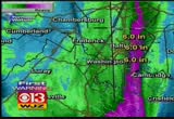
mary's and portions of western dorchester down into portions of virginia. a little bit more on this. bernadette joins me. >> these numbers will start going up. the next round is on its way. we've had over nine inches of rain. the airport alone we've seen those numbers. over 7 1/2 at the naval acady. salisbury will be on the way up. now the thing is, there are a lot of warnings going on. flash flood warnings have been extended. you see all of those counties. this has been extended until 12:15 a.m. in addition to that, still officially a tornado watch if -- in effect through 7:00 tonight. that severe weather threat at been the biggest problem. underneath we're seeing coastal flood warnings. that's because the winds have been sustained at 20 to 25 miles an hour. this turned around to the northwest. the band shifted to the east, cranked our wind around to the now. i don't think that's the trend. it will not push the water back out tomorrow. we'll keep you updated. mary? >> wjz has been tracking the flooding conditions all day in baltimore county. derek valcourt
mary's and portions of western dorchester down into portions of virginia. a little bit more on this. bernadette joins me. >> these numbers will start going up. the next round is on its way. we've had over nine inches of rain. the airport alone we've seen those numbers. over 7 1/2 at the naval acady. salisbury will be on the way up. now the thing is, there are a lot of warnings going on. flash flood warnings have been extended. you see all of those counties. this has been extended until...
180
180
Sep 30, 2010
09/10
by
WJLA
tv
eye 180
favorite 0
quote 0
. >> tractor-trailer wreck was then it by north in virginia. this is the right side of the roadway. the one to take you live to a couple of pictures a year know what to expect. first of all, we will show you 395 here in washington boulevard. evokes a traffic has more of the rain. the camera will show what it looks like a maryland for the. >> thank you so much. it is 4:42. we at 66 degrees on this rainy tuesday. >> a very late night for lawmakers to run down some the last minute measures coming from the capital. >> he did not deserve to die. >> a creepy twist in a local murder. >> welcome back. investigators are trying to figure what caused a tour bus from pennsylvania to plunge off of a sky way. the bus driver was killed. 12 people including several children were hurt. they are expected to survive. and massive traffic in the area for several hours. investigators are searching for the gunmen responded for -- responsible for a double shooting in d.c. one of the victims died. victims -- police have arrested a suspect in response of will to -- a murder of a 21-your old. investigators ar
. >> tractor-trailer wreck was then it by north in virginia. this is the right side of the roadway. the one to take you live to a couple of pictures a year know what to expect. first of all, we will show you 395 here in washington boulevard. evokes a traffic has more of the rain. the camera will show what it looks like a maryland for the. >> thank you so much. it is 4:42. we at 66 degrees on this rainy tuesday. >> a very late night for lawmakers to run down some the last...
102
102
Sep 30, 2010
09/10
by
WBAL
tv
eye 102
favorite 0
quote 0
you will see that tropical moisture extends down to virginia and the carolinas. accumulation estimates pretty much right up the bay and on the western shore, four-7 inches so far with 5-10 inches with parts of calvert county. it looks like some of that area will get hit hard tonight. the western shore shifting over to the eastern shore, another 5 inches of rain may come down. flood warnings are up all over our region. there's also a tornado watch until 7:00 this evening. they may produce tornadoes. lots of other problems as the remnants of nicole comes our way. monitoring the conditions in downtown baltimore is jane miller. they are dealing with the wind pushing up the bay. >> i am standing at the harbor and behind me i can feel the wind against my back. we will show you what you were talking about. this is the promise not area. -- promenade. all that area and the waterfront, everyone is keeping a close eye on that water level. the safety manager of the baltimore national aquarium kept watch on the rising water levels around the harbor. >> is this starts flooding
you will see that tropical moisture extends down to virginia and the carolinas. accumulation estimates pretty much right up the bay and on the western shore, four-7 inches so far with 5-10 inches with parts of calvert county. it looks like some of that area will get hit hard tonight. the western shore shifting over to the eastern shore, another 5 inches of rain may come down. flood warnings are up all over our region. there's also a tornado watch until 7:00 this evening. they may produce...
293
293
Sep 30, 2010
09/10
by
CNN
tv
eye 293
favorite 0
quote 0
but a couple of scares on virginia beach proper. so heavy, heavy rain with this. boy, i'll tell you what, wilmington has just gotten pounded with rain for the past four days now. 20 inches of rainfall. and they'll get several more today. so this is the most rain that they've ever seen, at least in a three-day period, let alone, a four or five-day period. you can see it continues to stream in here. so that's going to be the main issue. and then also some winds. you see winds gusting over 40 miles an hour in north carolina. last night in south carolina, we had a wind gust measured at over 60 miles an hour. society saturation of the ground, coupled with a little bit of wind, you're going to see trees down and power outages. this food watch goes all the way up to the canadian border. this say huge, huge system affecting a lot of people. ground stop at teterboro. you're not flying there? >> no, i'm not in that league. >> a lot of major metropolitan airports are under significant delays. >> i notice delta has canceled at least one flight from atlanta to new york. >> the
but a couple of scares on virginia beach proper. so heavy, heavy rain with this. boy, i'll tell you what, wilmington has just gotten pounded with rain for the past four days now. 20 inches of rainfall. and they'll get several more today. so this is the most rain that they've ever seen, at least in a three-day period, let alone, a four or five-day period. you can see it continues to stream in here. so that's going to be the main issue. and then also some winds. you see winds gusting over 40...
159
159
Sep 30, 2010
09/10
by
MSNBC
tv
eye 159
favorite 0
quote 0
more than five inches of rain fallen in participants of virginia and washington, d.c. prompting flash flood watches and warnings. we have meteorologists and reporters all along the east coast. we begin with the weather channel's jeff morrow, who is in washington, d.c. a couple hours ago we couldn't see you. now it looks a
more than five inches of rain fallen in participants of virginia and washington, d.c. prompting flash flood watches and warnings. we have meteorologists and reporters all along the east coast. we begin with the weather channel's jeff morrow, who is in washington, d.c. a couple hours ago we couldn't see you. now it looks a
196
196
Sep 30, 2010
09/10
by
WJLA
tv
eye 196
favorite 0
quote 0
. >>> two virginia, we are keeping an eye armed other areas -- keeping an eye on other areas known to flood. courtney robinson continues coverage from old town alexandria. >> rain, rain, and more rain -- it hit early, coming down hard and fast. just off of old courthouse road in vienna, our camera caught two cars in trouble. the water wreaked havoc. >> traffic is backed up on 95. it is really challenging. >> old town alexandria is prepared. the city is giving residence at sand bags. this man said water hits them first. >> i am perfected the technique. it is a big help. anyone who is brave enough to ride a bleak in the rain, i will give you a discount. >> each time it pours, the river rises, and high tides means water's going into the street. >> i do not let it stop me. >> residents say they have seen much worse. >> i do not think it will hit too hard. >> she was wrong. the water has come in. we are standing on king street. we are getting ready to be at high tide. this street was completely clear 30 minutes ago. now, you can see several inches under water. not to fund. >> in just -- no
. >>> two virginia, we are keeping an eye armed other areas -- keeping an eye on other areas known to flood. courtney robinson continues coverage from old town alexandria. >> rain, rain, and more rain -- it hit early, coming down hard and fast. just off of old courthouse road in vienna, our camera caught two cars in trouble. the water wreaked havoc. >> traffic is backed up on 95. it is really challenging. >> old town alexandria is prepared. the city is giving...
143
143
Sep 30, 2010
09/10
by
WJLA
tv
eye 143
favorite 0
quote 0
has been at work for us all day long, showing the further south -- the rain is further south toward virginia beach. this is the next batch. i cannot tell you exactly where the heaviest rain will fall. the indications are that it will be along and east of the i-95 corridor. this event will go mostly all night long with more heavy rain. 4.3 interest in prince frederick. -- 4.3 inches in prince frederick. 81 and 66, a warm, tropical, windy day with a lot of rain in the bucket. the overall area under a flash flood watch until about midnight tonight. a lot of things will change. this next big batch of rain is coming up from the south. buie at 81 degrees. definitely a tropical field in the air. by tomorrow, this latest storm system, which has incorporated what is left of tropical storm nicole, that will move up the chesapeake bay and make a turn to the right early in the morning. then we are on target to have a great stretch of whether as we head through the remaining afternoon hours into the weekend. as we head through the late- night hours, more heavy rain after 11:00 p.m. that is why you have t
has been at work for us all day long, showing the further south -- the rain is further south toward virginia beach. this is the next batch. i cannot tell you exactly where the heaviest rain will fall. the indications are that it will be along and east of the i-95 corridor. this event will go mostly all night long with more heavy rain. 4.3 interest in prince frederick. -- 4.3 inches in prince frederick. 81 and 66, a warm, tropical, windy day with a lot of rain in the bucket. the overall area...
180
180
Sep 30, 2010
09/10
by
WTTG
tv
eye 180
favorite 0
quote 0
. >> paul wagner inside and talk about some high water problems in virginia. didn't take long before the low- lying stretch of browns mill road was flooded in vienna. a car partly submerged. you see it there and turn around. >>> flooding problems in maryland as well. there have been reports of possible waterspouts and waves can causing coastal flooding and let's continue in maryland and bob barnard is live in annapolis and taking a beating from the heavy rains and mixing the tide, bob and that is a real mess. >> reporter: that's right, high tide is not for another 5 1/2 hours and that is coming out of the city dock harbor here and over the sidewalk. you can see, we'll follow it across here and that is underwater and the street here and businesses are closed and there he is on sand bags and in front of the ice crime shop and was basically damaged and destroyed, $40,000 in repairs them and spoke this time -- to them a short time ago. >> i'm unnerved by this because high tide is not supposed to be until 11:30. >> i get a few more sand bags, i will make it. >> not
. >> paul wagner inside and talk about some high water problems in virginia. didn't take long before the low- lying stretch of browns mill road was flooded in vienna. a car partly submerged. you see it there and turn around. >>> flooding problems in maryland as well. there have been reports of possible waterspouts and waves can causing coastal flooding and let's continue in maryland and bob barnard is live in annapolis and taking a beating from the heavy rains and mixing the...
197
197
Sep 30, 2010
09/10
by
WUSA
tv
eye 197
favorite 0
quote 0
look at the heavy rains through eastern north carolina and southeastern virginia. that's what's headed for the morning commute. we'll tighten up to close in view around the immediate metro area on the computer and we'll see moderate rain moving in from the metro area from the south. this is like a tropical conveyor belt, really. we'd like you to help sending them to the website, post on facebook or tweet, and go to twitter and please tag your tweets with dc flood and we'll put them on the air as soon as possible. overnight, rain and thunderstorms go into effect. lows of 60 and 65. i'll come back with breakdown of weather and rain fall amounts for your area. . >> down in alexander ria, crews are clearing drains hoping to clear the potential of high water. they've seen this sort of thing before. earlier tonight, trailer trucks loaded with sand bags made deposits at king and lee streets. meantime over in annapolis, the city is keeping a big eye on a aging dam. that 90-year-old dam's foundation is eroding and there are gaping cracks in the wall. regulators have deemed
look at the heavy rains through eastern north carolina and southeastern virginia. that's what's headed for the morning commute. we'll tighten up to close in view around the immediate metro area on the computer and we'll see moderate rain moving in from the metro area from the south. this is like a tropical conveyor belt, really. we'd like you to help sending them to the website, post on facebook or tweet, and go to twitter and please tag your tweets with dc flood and we'll put them on the air...
 Live Music Archive
 Librivox Free Audio
 Metropolitan Museum
 Cleveland Museum of Art
 Internet Arcade
 Console Living Room
 Books to Borrow
 Open Library
 TV News
 Understanding 9/11